In this topic we will discuss the Strike/Dip method for automatically generating hierarchy. Geologic hierarchy can be generated using either method (even automatically), however for geology that has a pronounced strike or dip, or contains lenses or pinch-outs the Strike/Dip method will produce the most accurate results. This method should be used carefully and all results should be checked against the original PGF file.
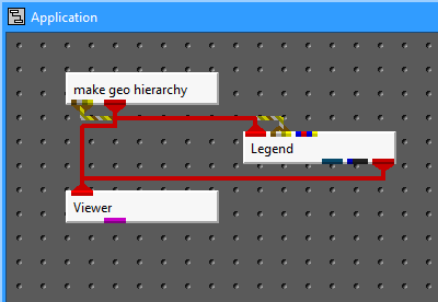
First instance a make_geo_hierarchy module, a Legend module and a Viewer and connect them as shown in the image below.
We have added a Legend to this network to help identify the material name of each layer.
Next load the pgf file "data\pregeology\dipping_strata_lens.pgf" in the make_geo_hierarchy module.
Set the "Z Scale" to 1.0 (this data set has a relatively small horizontal extent relative to its depth).
Then open the Az-El panel on the viewer and set the Azimuth to 225 and the elevation to zero. You should get the following image.

This view of the model shows the dip that is present in the geology, as well as a sand lens.
Our first step is to select "3.Silty-Sand" in the material selector.. Please note that all borings with Silty-Sand at the top are white while all others that do not exhibit this material at ground surface are grey (locked).

Click the WriteSurface button to write the top surface
Silty-Sand will automatically be selected in the material selector because the material is always the same for first two surfaces since they represent the top and bottom of the first layer (material).
Now, select the Strike/Dip method (vs. Layer Thickness). At this point you should see two horizontal transparent planes in your viewer.

The strike and dip values are used to define creates two visualization planes, a Top surface and a lower second parallel surface whose position is defined by the Tolerance slider. The upper surface is automatically positioned at a the highest possible (locked or automatically selected) sphere. No other point defining the surface we are working on can be above the Top surface. The lower plane is twice the tolerance below the top plane.
By increasing your tolerance value you allow the bottom of your layer to vary more, which will allow the module to create a "thicker" layer. However the maximum thickness should be defined by the bottom of all boring sections that contain the selected material. Shrinking your tolerance value will force the layer to parallel your strike and dip, but may result in creating extra layers as you progress through your model.
We would recommend that you experiment with different strike/dip values to get a feel for the process of selecting appropriate values. However, for this dataset you should set the strike to 42, and the dip to 30 S/W. You may feel that slightly different values are optimal, but for the workbook we recommend you use our values. Upon setting these values your viewer should show:

First examine the Tolerance at the default value of 11. Note that for this second surface, the bottoms of all Silty-Sand borings for the layer we're working on fall within the two visualization planes. This is the criteria for an acceptable tolerance. In this case the tolerance could be made much smaller, however in other models this could cause some of the borings to be split. If it is made too large, other borings (where this layer should be pinching out at ground surface) are affected. Rotate the model around with your mouse to see how well things fit.
Click the Write Surface button to write the 2ndSilty-Sand surface. At this point the planes will drop down to the next surface.

Now select 2.Sand in the material selector to begine the definition of the second layer (third surface).
Again rotate the model around with your mouse to see how well things fit.
Click the Write Surface button to write the 3rd surface which is defined as the bottom of "Sand"
Select Silt in the material selector
Rotate the model around with your mouse to see how well things fit.

Click the Write Surface button to write the 4th surface which is defined as the bottom of "Silt"
Silty-Sand becomes the selected material since there are no others present in any borings.
With our default tolerance of 11, this z-offset just barely encompasses the bottoms of Silty-Sand. If you experiment with smaller tolerances such as 10.0 you will see that the TIN surface is cutting the Silty-Sand in the eastern most borings. Our Tolerance of 11 is adequate but just barely.

Click the Write Surface button to write the 5th surface which is the bottom of another Silty-Sand layer.
Now things get interesting. We want to define the bottom of upper clay that represents the top of a sand lens inside the clay. In this case, the Tolerance dramatically affects the shape of the lens.
Set the Tolerance to 10.0. At this setting, all clay borings that include the sand lens will have reached the bottom of upper clay material and the borings without the lens will be split near the center of the lens. Note that a value of 9 would have inappropriately split some of the borings. Our previous value of 11 could be used, but would have pushed the piched out edges of the sand lens further down some of the borings.

Click the Write Surface button to write the 6th surface which is the bottom of the upper Clay layer.
Click the Write Surface button to write the 7th surface which is the bottom of the Sand lens.

Click the Write Surface button to write the 8th surface which is the bottom of the lower Clay layer.
Notice now how the generated surface no longer matches the strike and dip. This is because we have reached the bottom surface and the bottom of our borings which are defining this surface are not really the bottom of this gravel layer. These points are the bottoms of our borings representing the deepest point where geologic information was collected.They are not affeced by the Tolerance value. Since this is our final surface, the "Preserve Bottom" toggle is automatically selected which allows you to use these points to define the bottom of your model (not necessarily the bottom of the last layer".

Click the Write Surface button to write the 9th and final Gravel surface. The module will then automatically convert the gmf into a geo file.
© 1994-2018 ctech.com