Groundwater Vistas (GV) works with EVS/MVS in two ways. First, GV can import EVS/MVS geology files (*.gvg) to initiate the model grid and layer elevations. Second, GV can export both field and UCD format files for visualization or animation in EVS/MVS. The following sections describe how to accomplish these tasks in Groundwater Vistas.
When exporting data to EVS/MVS as either a UCD or Field file, Groundwater Vistas interpolates/extrapolates the block-centered model results to the nodes representing the corners of the model grid cells. This happens in all three dimensions so you end up with an extra layer of data, representing the top of layer one (1). This is done in order to convert data in GV that represents cells to the default nodal data paradigm in EVS/MVS. The advantage of this technique is that the grid will look the same as your grid in GV. The disadvantage is that there will be some loss of information, especially for point sources in transport models.
However, for UCD files only, the GV cell data is also exported as cell data. In this case, there is no interpolation or extrapolation performed on the model. The advantage is that your model output results exactly match the model in GV. The disadvantage in EVS/MVS is that cell data is somewhat more limited than nodal data and modules that subset cell data (e.g. for display of a contaminant plume) remove whole cells resulting in a blocky "Lego" like plume.
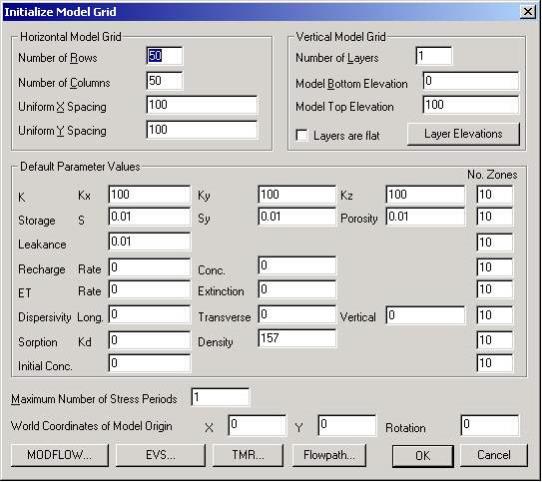
The EVS/MVS gvg file contains information about the finite-difference grid (rows, columns, layers, and spacings) and the elevation of each cell in each layer. A feature has been added in Groundwater Vistas Version 3 to read the gvg file at the start of a new model. The gvg file then determines the size of the model and location of the model in real-world coordinates. To create a groundwater model from a gvg file, select File/New in Groundwater Vistas. The following dialog is displayed:

You will see an EVS/MVS button at the bottom of the dialog. Simply click that button and go browse to find the *.gvg file created by EVS/MVS. Click OK when you are done. GV will get the number of rows, columns, and layers from the gvg file. In addition, row and column spacings and layer elevations will be obtained from the gvg file.
UCD files can be created by GV after the results of a model run are imported. This can happen directly after the model is finished or by selecting Plot/Import Results from the Groundwater Vistas menu. Whatever variables you import from MODFLOW/MT3D for display in GV are then exported to the UCD or Field file. When importing cell-by-cell flow terms from the MODFLOW runs, GV exports velocity components to the UCD file.
To export the UCD file, select File/Export in GV. A standard Windows file save dialog is displayed. Pull down the list of file types and scroll to the bottom. Choose "EVS UCD (*.inp)" as the file type and click the Save button.
EVS/MVS Field files are exported in the same way. Just change the file type to "EVS Field (*.fld)".
© 1994-2018 ctech.com