![]()
General Module Function
The geo_glyph module is used to place differing types of geometric objects (glyphs) according to the attributes at nodal locations. This functionality could be used for example to place a different glyph type for each geologic layer type in a model. The unique nature of geo_glyph (as compared with glyph) is that it can be passed multiple glyphs to be displayed according to the range of values in the input field.
The glyphs can be scaled, rotated and colored based on the input data. In a scalar data field, the objects can be scaled based on the magnitude of the scalar. The glyphs can represent the data field of one data component while being colored by another data component.
Module Input Ports
geo_glyph has two input ports.
Data passed to the first port (closest to the left) can have a mesh of any type and must have at least one nodal data component. The nodal data components can be vector or scalar.
The second port accepts the glyph object, usually read in with the load_glyph module.
Module Output Ports
geo_glyph has two output ports.
The leftmost output port creates a new unstructured mesh containing the positions of all the glyphs. Nodal data sent to this port contains the magnitude of the vector or scalar data.
The second output port sends the glyph geometry to the viewer.

Module Control Panel
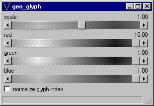
The control panel for geo_glyph is shown in the figure above. The scale slider determines the relative size of the glyphs. The Red, Green and Blue sliders control coloring of the glyphs. The normalize of toggle disables scaling of glyphs according to magnitude of the scalar value.
Related Modules
->advector
-> glyphs
© 1994-2018 ctech.com